India Flood News Monitor Dashboard
Overview
This project demonstrates a lightweight Web GIS dashboard for monitoring recent flood-related news and alerts across India. The dashboard brings information from multiple public news sources into a single interactive map, helping users quickly identify where flooding has been reported without manually checking multiple websites or news sources.
Key Features
- India-wide flood news monitoring
- Live RSS/Atom feed integration
- Flood-related keyword filtering
- Indian location identification
- Interactive map-based visualization
- Location-based news markers and popups
- Recent articles panel
- Source, headline, time, summary, and original news link
- Duplicate removal and server-side caching
- Last Updated timestamp
Workflow
- Fetch recent articles from public RSS/Atom feeds.
- Filter articles using flood and heavy-rain keywords.
- Remove duplicate and older articles.
- Identify Indian cities and states mentioned in the article content.
- Map recognized locations to geographic coordinates.
- Display identified flood events as markers on the India map.
- Show the related news information when a marker is selected.
Technologies Used
- HTML
- CSS
- JavaScript
- Node.js
- Express.js
- Leaflet
- RSS/Atom Feeds
- OpenStreetMap
- VS Code
Dataset
- Data Source: Public RSS/Atom news feeds
- Coverage: India
- Data Type: Recent flood-related news and alerts
Results
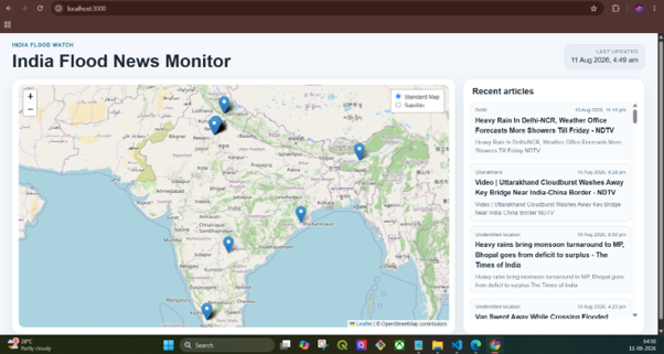
The dashboard provides a centralized view of reported flood events across India, displaying identifiable locations along with their related news information.
| Feature | Result |
|---|---|
| Geographic Coverage | India |
| News Sources | Multiple public RSS/Atom feeds |
| Flood Filtering | Implemented |
| Location Detection | Indian cities and states |
| Map Visualization | Interactive India map |
| News Information | Headline, source, time, summary and link |
| Data Handling | Duplicate removal and caching |
| Last Updated | Automated |
Future Improvements
- Integrate additional reliable news and alert sources.
- Improve automated location extraction.
- Add historical flood event analysis.
- Add filtering by date, state, and flood severity.
- Integrate satellite-based flood extent data.
- Deploy the dashboard as an online monitoring platform.