3D Modeling from Drone and Non-Drone Imagery
Overview
This project demonstrates the generation of 3D models from both drone and non-drone imagery using photogrammetry workflows. The workflow was tested on different image datasets, including banana plant imagery and drone images of a park area.
The workflow also generates high-level geospatial products such as Orthophoto, DSM, and DTM, which can support further analysis such as material-level damage assessment.
Key Features
- 3D model generation from drone imagery
- 3D model generation from non-drone imagery
- Orthophoto generation
- Digital Surface Model (DSM) generation
- Digital Terrain Model (DTM) generation
- Point cloud generation
- Photogrammetry workflow using WebODM and ODX
- Command-line processing workflow
Workflow
- Collect and prepare drone or non-drone images.
- Ensure sufficient image overlap for 3D reconstruction.
- Prepare the project and image directory.
- Process the imagery using WebODM or ODX.
- Generate the 3D textured model and point cloud.
- Generate Orthophoto, DSM, and DTM products.
- Visualize and inspect the generated outputs.
Technologies Used
- WebODM
- ODX
- Photogrammetry
- ExifTool
- MeshLab
- CloudCompare
- QGIS
- 3D Reconstruction
Dataset
- Drone Imagery: Park area
- Non-Drone Imagery: Banana plant imagery
- Example: 16 images used for banana 3D model generation
Results
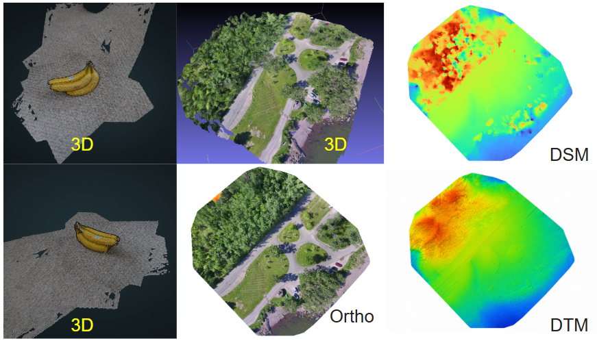
| Output | Result |
|---|---|
| Non-Drone Imagery | Banana imagery |
| Images Used | 16 images |
| Drone Imagery | Park area |
| 3D Model | Generated |
| Orthophoto | Generated |
| DSM | Generated |
| DTM | Generated |
| Point Cloud | Generated |
Future Improvements
- Integrate the processing workflow into a web-based platform.
- Automate processing for faster 3D reconstruction.
- Support client-provided property imagery for 3D model generation.
- Integrate generated products into damage assessment workflows.